Stefaan Verhulst
Paper by Protiva Adhikary, et al: “Data sharing is often viewed as essential for transboundary water cooperation, fostering trust and reducing uncertainty. Yet, evidence shows that data exchange alone does not ensure collaboration or resilience. This paper examines India–Bangladesh water relations since 1972, drawing on 28 expert interviews and documents. Despite sharing 54 rivers, cooperation remains narrow and reactive – limited to select rivers, monsoon periods, and raw data. Bangladesh’s calls for year-round sharing contrast with India’s caution, revealing power asymmetries. The study argues that data sharing is inherently political, and meaningful cooperation requires institutional commitment to equity, transparency, and climate resilience…(More)”.
Article by Carlo Cordasco: “…What none of these critics could have told you was that anaesthesia would make possible open-heart surgery, organ transplantation, neurosurgery, and the entire architecture of modern surgical specialisation. The benefit was not a more comfortable version of what surgeons had been doing. It was the appearance of a possibility space whose contents were inconceivable from inside the surgical practice of 1846.
Cases of this kind have a particular structure. An innovation arrives whose costs are perfectly legible, since they are visible against the baseline of the practice it is reorganising and can be measured with the practice’s existing instruments, while its most profound benefits depend on practices, institutions and concepts that do not yet exist at the moment of evaluation. Serious critics with domain expertise document the costs, often correctly, since costs of that kind are precisely what the evaluative vocabulary they have inherited is built to measure. There is no possible evaluation in the critical moment that could capture the benefits, because the vocabulary that would describe them is itself one of the things the innovation is going to bring into being.
Take dating apps. Eli Finkel and others have shown that app-mediated dating can produce choice overload, weaken commitment formation, and reduce the development of relationship skills that older modes of meeting cultivated more naturally. The empirical literature on loneliness, declining marriage rates among the young, and the collapse of casual in-person romantic initiation is now substantial. The critics are documenting real things, and their evidence is solid in just the way Harrison’s evidence on anaesthesia was solid.
What this evidence cannot capture is the set of effects that have emerged through the existence of the apps themselves and that nobody arguing about Tinder a decade ago could have specified. Public space itself has been quietly transformed, since the existence of an alternative channel for romantic initiation has weakened the normative status of an in-person approach to the point where women navigate streets, cafés and workplaces in ways that would have been unrecognisable in 1995. Some of what used to be ambient harassment in physical settings has been redistributed onto platforms where it is at least more controllable, since digital interactions can be filtered, blocked, reported and audited in ways that street and workplace harassment cannot…(More)”.
Book review by Luciano Magaldi Sardella of “The Credibility Crisis in Science by Thomas Plümper and Eric Neumayer: “…The scholarly landscape into which this book enters has been shaped by growing recognition of publication bias – the documented phenomenon that studies reporting positive or statistically significant findings are substantially more likely to be published than those reporting null results or failures to replicate. Research by Franco, Malhotra, and Simonovits found that among social science experiments that were peer-reviewed and approved before data collection, 91 per cent of published studies reported positive results, while only 72 per cent of the total conducted experiments did so. This systematic skewing of the published record, combined with growing awareness of questionable research practices (QRPs), has catalysed calls for reform across multiple disciplines. Plümper and Neumayer’s work addresses this ferment by providing a comprehensive taxonomy of how empirical findings become corrupted.
The authors’ central conceptual innovation lies in their tripartite taxonomy of empirical manipulation. They distinguish carefully between three categories often conflated in public discourse. First, outright data fabrication – the wholesale invention of findings – exemplified by the case of Diederik Stapel, the Dutch social psychologist who, between 2000 and 2011, fabricated data for at least 55 publications in leading journals including Science. Second, data manipulation – the alteration of raw data to produce desired outcomes. Third, and most significantly for their argument, “tweaking” – the intentional selection of research designs, model specifications, and analytical protocols based on the results they yield, often without explicit disclosure of these choices…(More)”.
Article by Richard A. Greenwald: “The “Two Cultures” lecture has aged into one of those texts that everyone mentions and nobody reads. The broad strokes are familiar: in 1959, C. P. Snow, an English chemist and novelist, stood before a Cambridge audience and announced that Western intellectual life had fractured into two distinct camps — scientists and humanists — who had ceased to communicate with one another. The scientists, in Snow’s telling, were optimistic modernizers with the “future in their bones”; the literary men were nostalgic reactionaries who couldn’t describe the Second Law of Thermodynamics and rather wished the future would not arrive. Snow found this tragic. Everyone nodded gravely. The essay became a perennial touchstone for handwringing about disciplinary silos and the need for well-rounded education, eventually landing on the Times Literary Supplement’s list of the hundred most influential books since World War II.
Here’s what’s funny about the whole thing: Snow was worried about the wrong problem. He fretted that humanists and scientists couldn’t communicate across their divide. What he couldn’t have anticipated is that six decades later, neither group would be setting the terms of public discourse at all.
Over the years, various observers have argued that the divide no longer exists, because the scientists won. In 1995, John Brockman claimed in his book The Third Culture that scientists were becoming the new public intellectuals, communicating directly with general audiences while literary intellectuals retreated into irrelevance.
He was half-right. Today a third culture does dominate public discourse, and it is technocratic. But it is not the culture of tweed-jacketed classicists nor of white-coated researchers. Both of those have been absorbed — digested, really — into a culture that didn’t exist when Snow was lecturing: the culture of venture capital, of pitch decks and product–market fit, of founders who look at the accumulated wisdom of human civilization and see a legacy codebase overdue for refactoring…(More)”.
Paper by Lin Kyi, Paul Gölz, Robin Berjon, and Asia J. Biega: “Obtaining meaningful and informed consent from users is essential for ensuring autonomy and control over one’s data. Notice and consent, the standard for collecting consent, has been criticized. While other individualized solutions have been proposed, this paper argues that a collective approach to consent is worth exploring. First, individual consent is not always feasible to collect for all data collection scenarios. Second, harms resulting from data processing are often communal in nature, given the interconnected nature of some data. Finally, ensuring truly informed consent for every individual has proven impractical.
We propose collective consent, operationalized through consent assemblies, as one alternative framework. We establish collective consent’s theoretical foundations and use speculative design to envision consent assemblies leveraging deliberative mini-publics. We present two vignettes: i) replacing notice and consent, and ii) collecting consent for GenAI model training. Our paper employs future backcasting to identify the requirements for realizing collective consent and explores its potential applications in contexts where individual consent is infeasible…(More)”.
Article by Ruchir Sharma: “The GDP report later this week is likely to show that economic growth in the US once again topped 2 per cent. But you wouldn’t have seen this coming in measures of the popular mood. Consumers keep spending, even as the gap between what they spend and the pessimism they express in surveys has never been higher.
Currently the two main consumer surveys, from the Conference Board and the University of Michigan, are at lows typical of a recession, not a steady expansion. In fact, lower confidence readings have been registered only twice over the last three decades, including during the global financial crisis of 2008.
The same disconnect is visible in key measures of business confidence. Several times since the pandemic, the ISM surveys of manufacturers and service firms have signalled a recession, which never came. The newer, broader business surveys from S&P have been closer to the mark, but despite a recent rebound, all these readings remain at levels weaker than the actual growth picture.
The monthly survey releases still get a lot of attention in the media and on Wall Street, which is a bit odd since the results are essentially broken. Falling response rates distort their findings. Social media seems to breed discontent regardless of how fast the economy is growing. In a polarised environment, partisan voters always think conditions are dismal when a rival party is in power. For these reasons and more, recent studies have found the reliability of major surveys falling not only in the US but in the Eurozone and UK as well.
Perhaps most significantly, surveys are naturally skewed by rising inequality. Unlike aggregate GDP growth figures, surveys give equal weight to every respondent. So they are never going to capture or foretell the full extent of GDP growth, when growth is increasingly dependent on the spending of a few. And that is what is happening now. In the US, the richest 10 per cent account for half of consumer spending, up from a third three decades ago. It should not be surprising the majority sounds pessimistic…(More)”.
Blog by Stefaan Verhulst: “For two decades, the open data community has worked to articulate what it means to make data fit for use, converging on the now-canonical FAIR principles: Findable, Accessible, Interoperable, and Reusable. As we argue in Moving Toward the FAIR-R Principles, this framework, though foundational, is no longer sufficient in an era of artificial intelligence. It must be extended to include a fifth commitment: Ready for AI.
The conversation over data readiness for the AI age is not confined to the public-interest domain. Parallel discussions have unfolded in the corporate sector, where the imperatives of AI readiness have been confronted at scale, and it is worth asking what the open data movement might learn from them.
McKinsey’s recent article, AI Data Readiness: The Key to Scaling Impact, is instructive in this regard. On its surface, the article reads as a memo to chief data officers diagnosing why corporate AI pilots so often stall before reaching production. It also offers some valuable lessons and principles for data stewards operating in the public interest, and who may be considering how to apply FAIR-R principles in practice.
In what follows, we treat this private-sector-focused article as a source of transferable knowledge while still remaining attentive to its limits. The caveat about limits is consequential, and we return to it below: in general, while enterprises optimize primarily for reliable outputs and cost avoidance, public-interest stewardship must also account for equity, openness, and public accountability. Some lessons therefore transfer cleanly, while others may require translation (or simply not apply at all)…(More)”.
Paper by Adam Zable, and Stefaan Verhulst: “This paper reports findings from a structured participatory foresight study comprising two expert forecasting studios convened by The GovLab between 2025 and 2026. The studios brought together nineteen senior practitioners spanning official statistics, digital and trade policy, open science, AI governance, geospatial systems, and public-sector innovation across multiple jurisdictions. Applying a qualitative signal-scanning methodology grounded in the horizon-scanning and anticipatory-governance traditions, we elicited, clustered, and thematically synthesized emerging developments in data access, governance,and reuse, and stress-tested them against practitioner experience. We identify seven convergent signals: (1) the open-data paradigm is under strain; (2) data ecosystems are becoming machine-centric and AI-mediated; (3) inference is reshaping the foundations of data governance;(4) data infrastructure is becoming harder to sustain; (5) governance is fragmenting across institutions and jurisdictions; (6) sovereignty and security are driving a turn toward strategic control; and (7) data-sharing models require stronger incentives and benefit-sharing mechanisms. We further map the reinforcing feedback loops that couple these signals, showing how interventions in one domain propagate risks and opportunities across the wider ecosystem. We argue that data governance is becoming inseparable from AI governance, digital public infrastructure, economic strategy, democratic resilience, and geopolitical competition, and we outline an agenda for anticipatory data governance capable of adapting before dependencies, risks, and missed opportunities become locked in. The contribution is diagnostic rather than predictive: the signals offer an evidence-informed framework for reasoning about structural shifts already underway, not a forecast of specific technological outcomes…(More)”.
Article by Stanford HAI: “Millions of Americans are affected by mental illness every year, yet the cost of therapy remains out of reach for many, and a shortage of licensed clinicians means that even those with insurance often wait months for an appointment. Into this void has stepped a rapidly expanding market of AI-powered tools, including chatbots that provide therapeutic counseling and apps that offer cognitive behavioral therapy exercises on demand. Children and adults also seek out general-purpose chatbots like ChatGPT and “companion” bots such as those offered by Character.ai and Replika in times of loneliness or emotional distress.
There are promising potential upsides to the use of AI in mental health care: greater access, lower cost, tools that could extend the reach of an overstretched system, and a form of social and emotional support for people experiencing loneliness. But these promises also entail risk. Absent clear regulation and standardized third-party testing, these tools risk delivering substandard care and putting users in danger. News headlines abound about minors developing unhealthy emotional attachments to chatbots, users in crisis receiving harmful or inadequate responses, and research showing that general-purpose AI chatbots commonly miss warning signs.
AI’s role in mental health care is growing fast, and legislators are struggling to keep pace. To date, most legislative activities have happened in states, which have introduced more than 140 bills related to AI use in mental health contexts. Federal legislation is pending, but so far has been narrowly focused on protection of minors. This fragmented policy landscape is further hindered by a perpetually lagging evidence base: Many purpose-built AI mental health tools lack validated outcomes and representative samples, and are rarely evaluated with rigorous study designs. Meanwhile, the models powering general-purpose chatbots update so rapidly that safety research findings quickly become outdated…(More)”.
Blog by Milena Jael Silva: “Open data remains a democratic achievement, and a necessary one. It widened access to information once held inside ministries, laboratories, firms or platforms, and gave public actors, researchers and citizens stronger grounds for scrutiny and reuse. Yet access is no longer where the governance problem ends.
Data become powerful through what happens after publication. They are cleaned, linked, modelled, ranked, mapped and translated into decisions. A portal may release a signal, while the machinery that turns that signal into authority sits elsewhere. The sharper question is therefore not only whether data are open. It is whether public institutions and relevant communities retain the capacity to make, inspect and contest the claims made from them.
Take a coastal municipality. It publishes drainage maps, flood records, shoreline observations, land-use data, infrastructure files and social vulnerability indicators. The portal is functional, the licences permissive and the metadata adequate. By conventional open data standards, the municipality appears compliant. An external provider then combines those public signals with remote sensing, proprietary modelling and a hosted interface. It sells the municipality a climate-risk dashboard that ranks neighbourhoods, assigns exposure scores, proposes investment priorities and makes some zones appear less viable. Elected officials can see the colours, planners can export the maps and consultants can cite the ranking. Yet the municipality cannot reproduce the classifications, inspect all thresholds or fully argue with the uncertainty. Who, at that point, governs the coast?
This is closed inference: a post-publication asymmetry in which data may be open, shared or technically accessible, while the capacity to transform them into authoritative interpretation remains concentrated, closed or insufficiently accountable. It appears downstream, where accessible signals become classifications, forecasts, priorities and a working basis for public decisions.
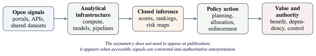
At this point, the issue is not that information is hidden. The data may circulate, the dashboard may be visible, and the report may be public. Still, the authority to say what the data mean may sit inside an analytical infrastructure that public actors do not command. Transparency shows that information exists; it does not necessarily reveal how significance is assigned, how uncertainty is handled, or how an output becomes a reason to act…(More)”.