Martin Brandt and Kjeld Rasmussen in The Conversation: “The possibility that vegetation cover in semi-arid and arid areas was retreating has long been an issue of international concern. In the 1930s it was first theorized that the Sahara was expanding and woody vegetation was on the retreat. In the 1970s, spurred by the “Sahel drought”, focus was on the threat of “desertification”, caused by human overuse and/or climate change. In recent decades, the potential impact of climate change on the vegetation has been the main concern, along with the feedback of vegetation on the climate, associated with the role of the vegetation in the global carbon cycle.
Using high-resolution satellite data and machine-learning techniques at supercomputing facilities, we have now been able to map billions of individual trees and shrubs in West Africa. The goal is to better understand the real state of vegetation coverage and evolution in arid and semi-arid areas.
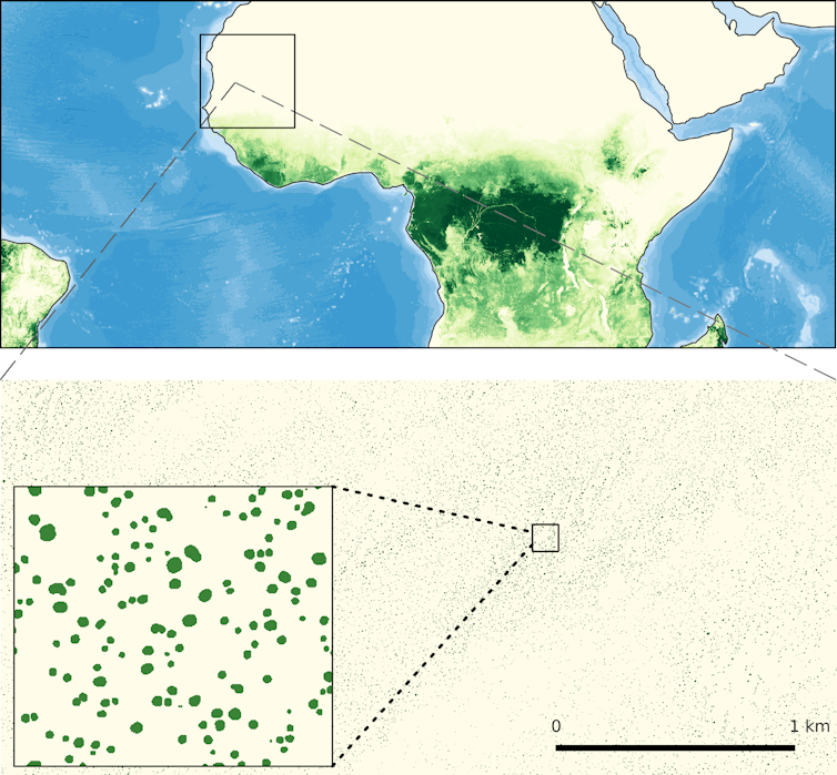
Finding a shrub in the desert – from space
Since the 1970s, satellite data have been used extensively to map and monitor vegetation in semi-arid areas worldwide. Images are available in “high” spatial resolution (with NASA’s satellites Landsat MSS and TM, and ESA’s satellites Spot and Sentinel) and “medium or low” spatial resolution (NOAA AVHRR and MODIS).
To accurately analyse vegetation cover at continental or global scale, it is necessary to use the highest-resolution images available – with a resolution of 1 metre or less – and up until now the costs of acquiring and analysing the data have been prohibitive. Consequently, most studies have relied on moderate- to low-resolution data. This has not allowed for the identification of individual trees, and therefore these studies only yield aggregate estimates of vegetation cover and productivity, mixing herbaceous and woody vegetation.
In a new study covering a large part of the semi-arid Sahara-Sahel-Sudanian zone of West Africa, published in Nature in October 2020, an international group of researchers was able to overcome these limitations. By combining an immense amount of high-resolution satellite data, advanced computing capacities, machine-learning techniques and extensive field data gathered over decades, we were able to identify individual trees and shrubs with a crown area of more than 3 m2 with great accuracy. The result is a database of 1.8 billion trees in the region studied, available to all interested….(More)”