A blog post by Peter Hargreaves: “…We find ourselves in a “golden age for satellite exploration”. ‘Big Data’ from satellite Earth observation – hereafter denoted ‘EO’ – could be an important part of the solution to the shortage of socioeconomic data required to inform several of the goals and targets that compose the United Nations (UN) Sustainable Development Goals (SDGs) [hyperlink]. In particular, the goals that pertain to socioeconomic and human wellbeing dimensions of development. EO data could play a significant role in producing the transparent data system necessary to achieve sustainable development….
Census and nationally representative household surveys are the medium through which most socioeconomic data are collected. It is impossible to understand socioeconomic conditions without them – I cannot stress this enough. But they have limitations, particularly in terms of cost and spatio-temporal coverage. In an ideal world, we would vastly upscale the spatial and temporal reporting of these surveys to cover more places and points in time. But this mass enumeration would be prohibitively expensive and *logistically impossible*. Imagine the quantity of data produced and the burden placed upon National Statistics Offices (NSOs) and governmental institutions? The 2030 end point for the SDGs would be upon us before much of the data was processed leaving very little time to use the outputs for policy.
This is where unconventional data enters the debate, and in this sphere – that of measuring socioeconomic conditions for development – EO data is unconventional. EO data has considerable potential to augment survey and census data for measuring rural poverty development in rural spaces, especially during intercensal periods, and where ground data are patchy, or non-existent. While on the subject, there is an important point to make: you can’t use EO to understand everything about a particular context. It does not matter how elaborate the model or the effort put in. Quite simply, EO cannot give you the full picture.
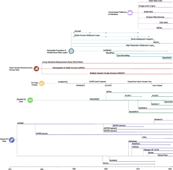
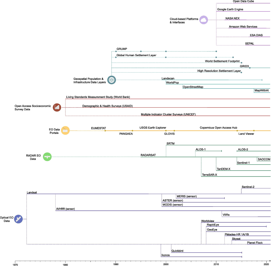
What EO *does* have is a five-decade temporal legacy (most platforms and data products are near continuous), and its broadly open access with low to negligible acquisition costs. EO data is also availabile across multiple spatial resolutions and is often easily comparable and complementary. When we say, ‘five-decade temporal legacy’, this means that there are roughly 50 years of EO data (if we use the Landsat program as an anchor). Not all EO platforms have operated across the whole timeline – Figure 1 below offers an idea of when different platforms were launched and for how long they were, or have been, operational. What’s more, data will be increasingly available and accessible, catalysed by technological innovation and investment in public and private ventures. A lot of this data is open access e.g. EO platforms operated by NASA or the ESA Copernicus programme, which include Landsat, MODIS, AVHRR, VIIRs, and the Sentinels amongst others. Meanwhile, the availability of EO data across multiple spatial resolutions enables disaggregation of data alongside survey and census data for subnational monitoring of socioeconomic conditions….(More)”.